Hurricane Sandy was a tropical cyclone that devastated portions of the Caribbean Sea, Mid-Atlantic States, and Northeastern United States during late October 2012, with lesser impacts in the Southeastern United States, Midwestern United States states and Eastern Canada. Sandy, classified as the eighteenth Tropical cyclone and tenth hurricane of the 2012 Atlantic hurricane season, was a Category 2 storm at its peak intensity. While it was a Category 1 storm off the coast of the Northeastern United States, the storm became the largest North Atlantic tropical hurricane on record (as measured by diameter with winds spanning 1,100 miles). Preliminary estimates of losses due to damage and business interruption are estimated at $65.6 billion (2012 USD), which would make it the second-costliest Atlantic hurricane behind only Hurricane Katrina. At least 253 people were killed along the path of the storm in seven countries
Sandy developed from a tropical wave in the western Caribbean Sea on October 22, quickly strengthened and was upgraded to Tropical Storm Sandy six hours later. Sandy moved slowly northward toward the Greater Antilles and gradually intensified. On October 24, Sandy became a hurricane, made landfall near Kingston, Jamaica, a few hours later, re-emerged into the Caribbean Sea and strengthened into a Category 2 hurricane. On October 25, Sandy hit Cuba, then weakened to a Category 1 hurricane. Early on October 26, Sandy moved through the Bahamas. On October 27, Sandy briefly weakened to a tropical storm and then restrengthened to a Category 1 hurricane. Early on October 29, Sandy curved north-northwest and then moved ashore near Atlantic City, New Jersey as a "post-tropical cyclone" with hurricane-force winds. Shortly after, media outlets were calling the storm "Superstorm Sandy".
In Jamaica, winds left 70% of residents without electricity, blew roofs off buildings, killed one, and caused about $55.23 million in damage. In Haiti, Sandy's outer bands brought flooding that killed at least 54, caused food shortages, and left about 200,000 homeless. In the Dominican Republic, two died. In Puerto Rico, one man was swept away by a swollen river. In Cuba, there was extensive coastal flooding and wind damage inland, destroying some 15,000 homes, killing 11, and causing $2 billion in damage. In The Bahamas, two died amid an estimated $300 million in damage. In Canada, two were killed in Ontario and an estimated $100 million in damage was caused throughout Ontario and Quebec.
In the United States, Hurricane Sandy affected 24 U.S. states, including the entire eastern seaboard from Florida to Maine and west across the Appalachian Mountains to Michigan and Wisconsin, with particularly severe damage in New Jersey and New York. Its storm surge hit New York City on October 29, flooding streets, tunnels and subway lines and cutting power in and around the city. Damage in the US is estimated at over $63 billion.
==Meteorological history== Hurricane Sandy began as a low pressure system which developed sufficient organized convection to be classified as a tropical depression on October 22 south of Kingston, Jamaica. It moved slowly at first due to a ridge to the north. Low wind shear and warm waters allowed for strengthening, and the system was named Tropical Storm Sandy late on October 22. Early on October 24, an eye began developing, and it was moving steadily northward due to an approaching trough. Later that day, the NHC upgraded Sandy to hurricane status about 65 miles south of Kingston, Jamaica. At about 1900 UTC that day, Sandy made landfall near Kingston with winds of about 80 mph. Just offshore Cuba, Sandy rapidly intensified to winds of 110 mph and at that intensity it made landfall just west of Santiago de Cuba at 0525 UTC on October 25.
After Sandy exited Cuba, the structure became disorganized and it turned to the north-northwest over the Bahamas. By October 27, Sandy was no longer fully tropical, and despite strong shear, it maintained convection due to influence from an approaching trough; the same trough turned the hurricane to the northeast. After briefly weakening to a tropical storm, Sandy re-intensified into a hurricane, and on October 28 an eye began redeveloping. The storm moved around an upper-level low over the eastern United States and also to the southwest of a ridge over Atlantic Canada, turning it to the northwest. Sandy reached a secondary peak of 90 mph on October 29, around which time it had a wind diameter of over 1,000 nautical miles. The convection diminished while the hurricane accelerated toward the New Jersey coast, and the hurricane was no longer tropical by 2300 UTC on October 29. An hour later at about 8:00pm EDT, Sandy made landfall about 5 miles southwest of Atlantic City, New Jersey, with winds of 90 mph. The remnants weakened over western Pennsylvania, degenerating into a remnant trough on October 31.
=== Relation to global warming === According to NCAR senior climatologist Kevin E. Trenberth, "The answer to the oft-asked question of whether an event is caused by climate change is that it is the wrong question. All weather events are affected by climate change because the environment in which they occur is warmer and moister than it used to be" He illustrates by pointing out that steroids in a baseball player's system do not cause home runs all by themselves but do make home runs more likely. UC Berkeley linguist George Lakoff describes this confusion as arising from the public's misunderstanding of the difference between "direct causation" and "systemic causation.
NOAA meteorologist Martin Hoerling attributed the "immediate cause" of Sandy to "little more than the coincidental alignment of a tropical storm with an extratropical storm." Trenberth agrees that the storm was caused by "natural variability" but adds that it was "enhanced by global warming".
One factor contributing to the storm's strength was additional energy from abnormally warm water off the North American East Coast, where global warming was identified as contributing 0.6°C of the 3°C above normal sea surface temperatures. As the temperature of the atmosphere increases, the capacity to hold water increases, leading to stronger storms and higher rainfall amounts.
As they drift north, Atlantic hurricanes typically are blown to the east and out to sea by the jet stream's prevailing winds. In Sandy's case, this typical pattern was blocked by a ridge of high pressure over Greenland resulting in a negative North Atlantic Oscillation, forming a kink in the jet stream, causing it to double back on itself off the East Coast. Sandy was caught up in this northwesterly flow. The blocking pattern over Greenland also stalled an arctic front which combined with the cyclone. Some scientists attributed this blocking pattern to global warming. Mark Fischetti of Scientific American argued that the jet stream's unusual shape was caused by the melting of Arctic ice. Noting that these blocking patterns are unusual in the fall but have been increasing, Masters said that three studies in 2011 found "that the recent record decline in Arctic sea ice could be responsible, since this heats up the pole, altering the Equator-to-pole temperature difference, forcing the jet stream to slow down, meander, and get stuck in large loops." Trenberth said that the null hypothesis would be that the negative North Atlantic Oscillation was just part of the oscillation's natural phases, and at present the influence of polar warming was speculative.
Measured sea level at New York and along the New Jersey coast has increased by a foot over the last hundred years. Climatologist Michael E. Mann attributes at least 1 foot of the 13-foot storm surge in lower Manhattan to global sea level rise.[1] Harvard geologist Daniel P. Schrag calls Hurricane Sandy's 13-foot storm surge an example of what will, by mid-century, be the "new norm on the Eastern seaboard".[2]
====Jamaica==== After the storm became a tropical cyclone on October 22, the Government of Jamaica issued a tropical storm watch for the entire island.[3] Early on October 23, the watch was replaced with a tropical storm warning and a hurricane watch was issued.[4] At 3 p.m. UTC, the hurricane watch was upgraded to a hurricane warning, while the tropical storm warning was discontinued.[5] In preparation of the storm, many residents stocked up on supplies and reinforced roofing material. Acting Prime Minister Peter Phillips urged people to take this storm seriously, and also to take care of their neighbors, especially the elderly, children, and disabled. Government officials shut down schools, government buildings, and the airport in Kingston on the day prior to the arrival of Sandy. Meanwhile, numerous and early curfews were put in place to protect residents, properties, and to prevent crime.[6]
====Haiti==== Shortly after Jamaica issued its first watch on October 22, the Government of Haiti issued a tropical storm watch for Haiti.[7] By late October 23, it was modified to a tropical storm warning.[8]
====Cuba==== The Government of Cuba posted a hurricane watch for the Cuban Provinces of Camagüey, Granma, Guantánamo, Holguín, Las Tunas, and Santiago de Cuba at 1500 UTC on October 23.[5] Only three hours later, the hurricane watch was switched to a hurricane warning.[9]
====Bahamas==== The Government of the Bahamas, at 1500 UTC on October 23, issued a tropical storm watch for several Bahamian islands, including the Acklins, Cat Island, Crooked Island, Exuma, Inagua, Long Cay, Long Island, Mayaguana, Ragged Island, Rum Cay, and San Salvador Island.[5] Later that day, another tropical storm watch was issued for Abaco Islands, Andros Island, the Berry Islands, Bimini, Eleuthera, Grand Bahama, and New Providence.[9] By early on October 24, the tropical storm watch for Cat Island, Exuma, Long Island, Rum Cay, and San Salvador was upgraded to a tropical storm warning.[10]
===Bermuda=== At 11:15 a.m. EDT (1515 UTC) on October 26, the Bermuda Weather Service issued a tropical storm watch for Bermuda, reflecting the enormous size of the storm and the anticipated wide-reaching impacts.[11]
White House conference with FEMA and Department of Homeland Security in preparation for arrival of the hurricane.
Template:Wikinews Much of the East Coast of the United States, in Mid-Atlantic and New England regions, had a good chance of receiving gale-force winds, flooding, heavy rain and possibly snow early in the week of October 28 from an unusual hybrid of Hurricane Sandy and a winter storm producing a Fujiwhara effect.[12] Government weather forecasters said there was a 90% chance (the chance having increased from 60% on October 24), that the East Coast would be impacted by the storm. Some media outlets began referring to the expected combination of the tropical system and storm front, a few days before Halloween, as "Frankenstorm,"[13] after Hydrometeorological Prediction Center forecaster Jim Cisco coined the term in an extended forecast discussion issued on October 25.[14][15] As coverage continued, many outlets began eschewing this term in favor of "superstorm",[16] with CNN in particular declaring an embargo on the use of the term "Frankenstorm" in its reporting, citing sensitivity concerns.[17] Utilities and governments along the East Coast attempted to head off long-term power failures that Sandy might cause. Power companies from the Southeast to New England alerted independent contractors to be ready to help repair storm damaged equipment quickly and asked employees to cancel vacations and work longer hours. Researchers from Johns Hopkins University, using a computer model built on power outage data from previous hurricanes, conservatively forecast that 10 million customers along the Eastern Seaboard would lose power from the storm.[18] In New Jersey, where the storm was expected to come ashore, Jersey Central Power & Light told employees to be prepared for extended shifts.[19]
President Obama discusses preparations for Hurricane Sandy
Through regional offices in Atlanta, Philadelphia, New York City, and Boston, the Federal Emergency Management Agency (FEMA) monitored Sandy and closely coordinated with state and tribal emergency management partners in Florida and the Southeast, Mid-Atlantic and New England states.[20]President Obama signed emergency declarations on October 28 for several states expected to be impacted by Sandy, allowing them to request federal aid and make additional preparations in advance of the storm.[21]
Flight cancellations and travel alerts on the U.S. East Coast were put in place in the Mid-Atlantic and the New England areas,[22] Over 5,000 commercial airline flights scheduled for October 28 and October 29 were canceled by the afternoon of October 28.[23] and Amtrak canceled some services through October 29 in preparation for the storm.[24]
The National Guard and U.S. Air Force put as many as 45,000 personnel in at least seven states on alert for possible duty in response to the preparations and aftermath of Sandy.[25]
Southeast[]
=====Florida===== Sandy brought tropical-storm force winds and rain to South Florida from October 25–27,[26][27] causing some closures and some cancellations of activities at schools in Palm Beach, Broward and Miami-Dade counties.[28] Schools on the Treasure Coast also announced closures for October 26, in anticipation of Sandy.[29] Storm surge from Sandy also caused flooding and beach erosion along coastal areas in South Florida.[30] A Russian, intelligence-gathering ship, was allowed to stay in Jacksonville to avoid Sandy; the port is not far from Kings Bay Naval Submarine Base.[31]
=====North Carolina===== On October 26, North Carolina Governor Beverly Perdue declared a state of emergency for 38 eastern counties in anticipation of Hurricane Sandy, taking effect October 27.[32] By Monday, October 29, the state of emergency was extended to 24 counties in western North Carolina, with up to a foot of snow attributed to Sandy anticipated in higher elevations. The National Park Service closed at least five sections of the Blue Ridge Parkway.[33]
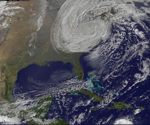
A satellite image of the storm on October 29, with most of the U.S. coastline artificially highlighted. The entire east coast is visible, with a cloudless Florida coast seen at the bottom of the image and the outline of the coast of Maine at the top right.
=====Virginia===== The U.S. Navy sent more than twenty seven ships and forces to sea from Norfolk Naval Base, for their protection.[34] Governor McDonnell authorized the National Guard to activate 630 personnel ahead of the storm.[35]Republican Party presidential candidate Mitt Romney canceled campaign appearances scheduled for October 28 in Virginia Beach, Virginia, and New Hampshire October 30 because of Sandy. Vice President Joe Biden canceled his appearance on October 27 in Virginia Beach and an October 29 campaign event in New Hampshire.[36] President Barack Obama canceled a campaign stop with former President Bill Clinton in Virginia scheduled for October 29, as well as a trip to Colorado Springs, Colorado, the next day because of the impending storm, and said he will remain in Washington D.C.[37] As of the morning of November 2, 6,100 customers were without power, down from more than 180,000.[38]
Mid-Atlantic[]
=====Washington, D.C.===== On October 26, Washington, D.C. Mayor Vincent Gray declared a state of emergency.[39] That same day the governors of Pennsylvania, Maryland, and Virginia also declared states of emergency in preparation of the approaching storm.[34]
The United States Office of Personnel Management announced federal offices in the Washington, D.C. area would be closed to the public on October 29–30.[40] In addition, Washington D.C. Metro service, both rail and bus, was canceled on October 29 due to expected high winds, the likelihood of widespread power outages, and the closing of the federal government.[41] President Obama declared a state of emergency for the District of Columbia.[42] The Smithsonian Institution closed for the day of October 29.[43]
=====Maryland===== On October 27, Smith Island residents were evacuated with the assistance of the Maryland Natural Resources Police, Dorchester County opened two shelters for those in flood prone areas, and Ocean City initiated Phase I of their Emergency Operations Plan.[44][45][46] Baltimore Gas and Electric Co. has been putting workers on standby and making plans to bring in crews from other states.[19] On October 28, President Obama declared an emergency in Maryland and signed an order authorizing the Federal Emergency Management Agency to aid in disaster relief efforts.[47] Also, numerous areas were ordered to be evacuated including part of Ocean City, Worcester County, Wicomico County, and Somerset County.[48][49] As of October 27, 2012, there are serious possibilities that more than a hundred million tons of dirty sediment mixed with tree limbs and debris floating behind Conowingo Dam may be eventually poured into the Chesapeake Bay, posing a potential environmental threat.[50]
The Maryland Transit Administration canceled all service for October 29 and October 30. The cancellations applied to buses, light rail, Amtrak and MARC train service.[51] On October 29, six shelters opened in Baltimore and early voting was canceled for the day.[43] Maryland Insurance Commissioner Therese M. Goldsmith activated an emergency regulation requiring pharmacies to refill prescriptions regardless of their last refill date.[52] On October 29, the Chesapeake Bay Bridge over the Chesapeake Bay and the Millard E. Tydings Memorial Bridge and Thomas J. Hatem Memorial Bridge over the Susquehanna River were closed to traffic in the midday hours.[53]
=====Delaware===== On October 28, Governor Markell declared a state of emergency, with coastal areas of Sussex County evacuated. Delaware Route 1 through Delaware Seashore State Park was closed due to flooding.[54] Delaware roads will be closed to the public after 5 a.m., except for emergency and essential personnel.[55] Tolls on I-95 and Delaware Route 1 in the state have been waived.[56]
Airmen of the New Jersey National Guard's 108th Wing assemble before being sent to assist at various emergency shelters.
In Cape May County, officials advised residents on barrier islands to evacuate on October 26. There was also a voluntary evacuation for Mantoloking, Bay Head, Barnegat Light, Beach Haven, Harvey Cedars, Long Beach, Ship Bottom, and Stafford in Ocean County.[57][58][59]New Jersey GovernorChris Christie ordered all residents of barrier islands from Sandy Hook to Cape May to evacuate, and closed all Atlantic City casinos. Tolls were suspended on the northbound Garden State Parkway and the westbound Atlantic City Expressway starting at 6 a.m. on October 28.[60] President Obama signed an emergency declaration for New Jersey, allowing the state to request federal funding and other assistance for actions taken before Sandy's landfall.[61]
On October 28, Hoboken Mayor Dawn Zimmer ordered residents of basement and street-level residential units to evacuate, due to possible flooding.[62] On October 29, residents of Logan Township were ordered to evacuate.[63]Jersey Central Power & Light told employees to prepare to work extended shifts.[19][64]
On October 29, Sandy made landfall near Atlantic City.[65] Most schools, colleges and universities were closed October 29, and at least 509 out of 580 school districts were closed October 30.[19][64]
=====Pennsylvania===== Philadelphia Mayor Michael Nutter asked residents in low-lying areas and neighborhoods prone to flooding to leave their homes by 2 p.m. EDT October 28 and move to safer ground.[66] The Philadelphia International Airport suspended all flight operations for October 29.[67] On October 29, Philadelphia shut down its mass transit system.[43] On October 28, Harrisburg Mayor Linda D. Thompson declared a state of disaster emergency for the city to go into effect at 5 a.m. October 29. Electric utilities in the state are bringing in crews and equipment from other states like New Mexico, Texas and Oklahoma, to assist with restoration efforts.[68]
Avenue C in Manhattan's East Village was flooded shortly before a massive explosion at the Consolidated Edison power substation on the street took out power to the neighborhood[69]
On October 26, New York GovernorAndrew Cuomo declared a state of emergency for every county in the state. He also asked for a pre-disaster declaration to better access federal assistance.[70] Later that day, President Obama signed an emergency declaration for the state of New York.[71]
All state courts were closed on October 29, except for arraignments and emergency applications.[72]
Major carriers canceled all flights into and out of JFK, LaGuardia, and Newark-Liberty airports,[72] and the Metro North and Long Island Rail Roads suspended service beginning 7 p.m. October 27; these commuter rail services were not fully restored as of November 2.[72] The Tappan Zee Bridge was closed October 29 at 4 p.m. EDT due to wind conditions.[73]
======Long Island====== Nassau County ExecutiveEd Mangano ordered voluntary evacuations of the South Shore storm surge area, which includes the area south of Sunrise Highway and north of Route 25A and in elevations 15 feet above sea level or less on the North Shore.[74]Template:Cn-span
In Suffolk County, mandatory evacuations were ordered for residents of Fire Island and in surge zone areas in Babylon, Islip, Brookhaven, Riverhead, Southampton and Southold. Shelters were opened at Hampton Bays High School, Sachem East High School, and the Brentwood High School Sonderling Building.[75] Most schools closed in Nassau and Suffolk counties on October 29, including Nassau Community College, Molloy College, Hofstra University and Adelphi University.[76]
Portions of the FDR Drive remained flooded on the Tuesday morning after the storm
On October 26, Mayor Michael Bloomberg originally told reporters that the city had begun taking precautions but that at that time there was no call for mandatory evacuations and no plans to suspend the city's mass transit or cancel school. But on October 28, Governor Cuomo ordered the MTA, including the subway, closed, and in a press conference immediately following Cuomo's announcement, Mayor Bloomberg ordered public schools closed on October 29.[77] He also ordered mandatory evacuations for Zone A, which comprises portions of Lower Manhattan, the Coney Island-Brighton Beach and Red Hook areas of Brooklyn, the entire Rockaways peninsula, much of Staten Island, City Island, and part of the Throggs Neck area of the Bronx. All these areas are near coastlines or waterways.[78] On October 28, officials activated the city's coastal emergency plan, with subway closings and the evacuation of residents in areas hit during Hurricane Irene in August 2011. More than 76 evacuation shelters were open around the city.[70]
The MTA announced that all subway, bus and commuter rail service would be suspended, beginning at 7 p.m. EDT on October 28.[79]Template:Cn-span After Hurricane Irene nearly submerged subways and tunnels in 2011,[80] entrances and grates were covered just before Sandy, but were flooded anyway.[81]
All PATH train service and stations were shut down at 12:01 a.m., October 29,[77] all bus carriers at the Port Authority Bus Terminal closed at 3 a.m., and 200 National Guard troops were deployed in the city.[82]Template:Cn-span The Brooklyn Battery Tunnel and Holland Tunnel closed at 2 p.m. EDT on October 29.[83][84]Template:Cn-span All NYC schools were closed for the week of the hurricane.[85]NYU Langone Medical Center canceled all surgeries and medical procedures, except for emergency procedures.[82] Additionally, one of NYU Langone Medical Center's backup generators failed on October 29, 2012, prompting the evacuation of hundreds of patients, including those from the hospital's various intensive care units.[86]Broadway theaters canceled all October 28 evening and October 29 performances.[72]
U.S. stock trading was suspended for October 29–30.[87]
Flooding in Marblehead, Massachusetts, caused by Hurricane Sandy on October 29.
Connecticut Governor Dannel Malloy partially activated the state's Emergency Operations Center on October 26[88] and signed a Declaration of Emergency the next day.[89] On October 28, President Obama approved Connecticut's request for an emergency declaration, and hundreds of National Guard personnel were deployed.[90] On October 29, Governor Malloy ordered road closures for all state highways.[91] Numerous mandatory and partial evacuations were issued in cities across Connecticut.[92]
Massachusetts Governor Deval Patrick ordered state offices to be closed October 29 and recommended schools and private businesses close. On October 28, President Obama issued a Pre-Landfall Emergency Declaration for Massachusetts. Several shelters were opened, and many schools were closed.[93][94] On October 28, Vermont Governor Peter Shumlin, New Hampshire Governor John Lynch, and Maine's Governor Paul LePage all declared states of emergency.[43][95][96]
Appalachia and the Midwest[]
=====Great Lakes region===== The National Weather Service issued a storm warning for Lake Huron on October 29 that called for wave heights of 26 feet, and possibly as high as 38 feet. Lake Michigan waves were expected to reach 19 feet, with a potential of 33 feet on October 30.[97] Flood warnings were issued in Chicago on October 29, where wave heights were expected to reach 18 to 23 feet along the Cook County shoreline and 25 feet in northwest Indiana.[98] Gale warnings were issued for Lake Michigan and Green Bay in Wisconsin until the morning of October 31, and waves of 33 feet in Milwaukee and 20 feet in Sheboygan were predicted for October 30.[99] The actual waves reached about 20 feet but were less damaging than expected.[100][101] The village of Pleasant Prairie, Wisconsin urged a voluntary evacuation of its lakefront area, though few residents signed up, and little flooding actually occurred.[99][101]Michigan was impacted by a winter storm system coming in from the west, mixing with cold air streams from the Arctic and colliding with Hurricane Sandy.[97] The forecasts slowed shipping traffic on the Great Lakes, as some vessels sought shelter away from the peak winds, except those on Lake Superior.[102][103] Approximately 120,000 people were without power in southeast Michigan the morning of October 30, with winds gusting to 50 mph.[104][105]Detroit-based DTE Energy says it has released 100 contract line workers to assist utilities along the eastern U.S. with storm response. Also CMS Energy Corp.'s Consumers Energy unit says the storm has also affected 1,200 of its 1.8 million Michigan customers.[106]Consumers Energy says it has released more than a dozen employees and 120 contract employees to assist in the eastern U.S.[107] Due to the widespread power outages, numerous schools had to close, especially in St. Clair County and areas along Lake Huron north of Metro Detroit. Wave heights on Lake Huron were reported to have reached 23 feet on the south side of the lake.[106]
Snow was reported in some parts of eastern Ohio and south of Cleveland. Snow and icy roads also were reported south of Columbus.[108] As far as the state's western edge, areas were under a wind advisory.[109] All departing flights at Cleveland Hopkins International Airport were canceled until October 30 at 3 pm.[110] Wind gusts at Cleveland Burke Lakefront Airport were reported at Template:Convert.[111] Hundreds of school districts canceled or delayed school across the state with at least 250,000 homes and businesses without power.[108] Damage was reported across the state including the Rock and Roll Hall of Fame which lost parts of its siding.[111]
=====Appalachian Mountains region===== West Virginia Governor Earl Ray Tomblin declared a state of emergency ahead of storm on October 29.[112] Up to 2 to 3 feet (0.6–0.9m) of snow was forecast for mountainous areas of the state.[113]
===Canada=== The Canadian Hurricane Centre issued its first preliminary statement on Hurricane Sandy on October 25 from Southern Ontario to the Canadian Maritimes,[114] with the potential for heavy rain and strong winds.[115] On October 29, Environment Canada issued severe wind warnings for the Great Lakes and St. Lawrence Valley corridor, from Southwestern Ontario as far as Quebec City.[116] On October 30, Environment Canada issued storm surge warnings along the mouth of the St. Lawrence River.[117] Rainfall warnings were issued for the Charlevoix region in Quebec, as well as for several counties in New Brunswick, and Nova Scotia, where 50 to 70 millimetres of rain was to be expected.[118][119][120] Freezing rain warnings were issued for parts of Northern Ontario.
==Caribbean==
Main article: Effects of Hurricane Sandy in the Greater Antilles
==Jamaica== Sandy was the first hurricane to directly hit Jamaica since Hurricane Gilbert, 24 years prior. Trees and power lines were snapped and shanty houses were heavily damaged, both from the winds and flooding rains. More than 100 fishermen were stranded in outlying Pedro Cays off Jamaica's southern coast.[121] Stones falling from a hillside crushed one man to death as he tried to get into his house in a rural village near Kingston.[122] The country's sole electricity provider, the Jamaica Public Service Company, reported that 70 percent of its customers were without power. More than 1,000 people went to shelters. Jamaican authorities closed the island's international airports, and police ordered 48-hour curfews in major towns to keep people off the streets and deter looting.[123] Most buildings in the eastern portion of the island lost their roofs.[124] Damage totaled $55.23 million throughout the country.[125]
==Hispaniola== In Haiti, which was still recovering from both the 2010 earthquake and the ongoing cholera outbreak, at least 54 people have died,[126] and an estimated 200,000 were left homeless as of late Monday October 29, as a result of four days of ongoing rain from Hurricane Sandy.[127] Heavy damage occurred in Port-Salut after rivers overflowed their banks.[128] In the capital of Port-au-Prince, streets were flooded by the heavy rains, and it was reported that "the whole south of the country is underwater".[129] Most of the tents and buildings in the city's sprawling refugee camps and the Cité Soleil neighborhood were flooded or leaking, a repeat of what happened earlier in the year during the passage of Hurricane Isaac.[124] Crops were also wiped out by the storm and the country would be making an appeal for emergency aid.[130] Damage in Haiti was estimated at $74 million (2012 USD).[131] In the month following Sandy, a resurgence of Cholera linked to the storm killed at least 44 people and infected more than 5,000 others.[132]
In the neighboring Dominican Republic, two people were killed and 30,000 people evacuated.[133] An employee of CNN estimated 70% of the streets in Santo Domingo were flooded.[134] One person was killed in Juana Díaz, Puerto Rico after being swept away by a swollen river.[133]
At least 55,000 people were evacuated before Hurricane Sandy's arrival.[135] While moving ashore, the storm produced waves up to 29 feet (9 meters) and a 6 foot (2 meter) storm surge that caused extensive coastal flooding.[136] There was widespread damage, particularly to Santiago de Cuba where 132,733 homes were damaged, of which 15,322 were destroyed and 43,426 lost their roof.[137] Electricity and water services were knocked out, and most of the trees in the city were damaged. Total losses throughout Santiago de Cuba province is estimated as high as $2 billion (2012 USD).[138] Sandy killed 11 people in the country – nine in Santiago de Cuba Province and two in Guantánamo Province; most of the victims were trapped in destroyed houses.[139][140] This makes Sandy the deadliest hurricane to hit Cuba since 2005, when Hurricane Dennis killed 16 people.[141]
====Bahamas==== A NOAA automated station at Settlement Point on Grand Bahama Island reported sustained winds of 49 mph (74 km/h) and a wind gust of 63 mph (102 km/h).[142] One person died from falling off his roof while attempting to fix a window shutter in the Lyford Cay area on New Providence. Another died in the Queen's Cove area on Grand Bahama Island where he drowned after the sea surge trapped him in his apartment.[133] Portions of the Bahamas lost power or cellular service, including an islandwide power outage on Bimini. Five homes were severely damaged near Williams's Town.[143]
===Bermuda=== Owing to the sheer size of the storm, Sandy also impacted Bermuda with high winds and heavy rains. On October 28, an F1 tornado touched down in Sandys Parish, damaging homes and businesses.[144] During a three-day span, the storm produced Template:Convert of rain at the L.F. Wade International Airport. The strongest winds were recorded on October 29: sustained winds reached Template:Convert and gusts peaked at Template:Convert.[145]
Damage to Casino Pier in Seaside Heights, New Jersey
A total of 24 U.S. states were in some way affected by Sandy. The hurricane caused tens of billions of dollars in damage in the United States, destroyed thousands of homes, left millions without electric service,[146] and killed at least 131 people in eight states, including 53 in New York, 37 in New Jersey, 13 in Pennsylvania, 11 in Maryland, six in West Virginia, five in Connecticut and three each in Virginia and North Carolina.[147] This makes Sandy the deadliest hurricane to hit the United States mainland since Hurricane Katrina in 2005, as well as the deadliest hurricane to hit the U.S. East coast since Hurricane Diane in 1955.[148]
Due to flooding and other storm-related problems, Amtrak canceled all Acela Express, Northeast Regional, Keystone, and Shuttle services for October 29 and 30.[149][150] More than 13,000 flights were canceled across the U.S. on October 29, and more than 3,500 were called off October 30.[151] From October 27 through early November 1, airlines canceled a total of 19,729 flights, according to FlightAware.[152]
As of early November 1, just over 4.8 million customers remained without power in 15 states and the District of Columbia, according to a CNN tally. The states with the most customers without power are New Jersey with 1,983,694 customers; New York with 1,514,147; Pennsylvania with 526,934; and Connecticut with 352,286.[153] The storm underlines the fragility of the aging American infrastructure, with an electricity network that is ranked lower than that of considerably poorer nations like Slovenia or Portugal.[154]Template:Double image The New York Stock Exchange and Nasdaq reopened on October 31 after a two-day closure for storm.[155] More than 1,500 FEMA personnel are along the East Coast working to support disaster preparedness and response operations, including search and rescue, situational awareness, communications and logistical support. In addition, 28 teams containing 294 FEMA Corps members are pre-staged to support Sandy responders. Three federal urban search and rescue task forces are positioned in the Mid-Atlantic and ready to deploy as needed.[156]
On November 2, the American Red Cross announced they have 4,000 disaster workers across storm damaged areas, with thousands more en route from other states. Nearly 7,000 people spent the night in emergency shelters across the region.[157]Hurricane Sandy: Coming Together, a live telethon on November 2 that featured rock and pop stars such as Bruce Springsteen, Billy Joel, Jon Bon Jovi, Mary J. Blige, Sting and Christina Aguilera, raised around $23 million dollars for American Red Cross hurricane relief efforts.[158]
As of November 5, 2012, the National Hurricane Center ranks Hurricane Sandy the second costliest US hurricane since 1900 in constant 2010 dollars, and the sixth costliest after adjusting for inflation, population and property values.[159] Their report also states that due to global warming the number of future hurricanes will "either decrease or remain essentially unchanged" overall, but the ones that do form will likely be stronger, with fiercer winds and heavier rains.[159]
Southeast[]
=====Florida===== High winds and waves washed sand onto coastal roads in southeastern Florida. The storm left power outages across the region, which left many traffic lights out of order.[160] The Coast Guard rescued two sea men in Volusia County off New Smyrna Beach on the morning of October 26.[161]Brevard and Volusia Counties schools canceled all extracurricular activities for October 26, including football.[162]
In east-central Florida, damage was minor, though the storm left about 1,000 people without power.[163] Airlines at Miami International Airport canceled more than 20 flights to or from Jamaica or the Bahamas, while some airlines flying from Fort Lauderdale–Hollywood International Airport canceled a total of 13 flights to the islands.[34]
Two panther kittens escaped from the White Oak Conservation Center in Nassau County after the hurricane swept a tree into the fence of their enclosure and were missing for 24 hours before being found in good health.[164]
The 180-foot sailing ship, Bounty, is shown nearly submerged during Hurricane Sandy in the Atlantic Ocean approximately Template:Convert southeast of Hatteras, North Carolina on Monday, October 29, 2012.
On October 28, Governor Bev Perdue declared a state of emergency in 24 western counties due to snow and strong winds.[165]North Carolina was spared from major damage through the late evening hours of October 28, though winds, rain, and inland snow could affect the state through October 30. Ocracoke and Highway 12 on Hatteras Island were flooded with up to Template:Convert of water, closing part of the highway, while 20 people on a fishing trip were stranded on Portsmouth Island.[166]
On October 29, the Coast Guard responded to a distress call from Bounty, which was built for the 1962 movie Mutiny on the Bounty. It was taking on water about 90 miles southeast of Cape Hatteras. Sixteen people were on board.[167] The Coast Guard said the 16 people abandoned ship and got into two lifeboats, wearing survival suits and life jackets.[168] The ship sank after the crew got off. As of mid-morning on October 29, the Coast Guard rescued 14. Another crew member was found hours later but was unresponsive and died later on. Only the captain remains missing.[169][170] On November 1, the Coast Guard suspended its search for Robin Walbridge, the captain of Bounty. The search lasted more than 90 hours, covering approximately 12,000 square nautical miles in the Atlantic Ocean.[171]
As of November 4, there were three Hurricane Sandy-related deaths.[172]
=====Virginia===== On October 29, snow was falling in parts of the state.[113] Gov. Bob McDonnell announced on October 30 that Virginia had been "spared a significant event", but cited concerns about rivers cresting as flood waters go into the major arteries. Virginia was awarded a federal disaster declaration, with Gov. McDonnell saying he was "delighted" that President Barack Obama and FEMA were on it immediately. At Sandy's peak, 200,000 customers were without power, and in Northern Virginia where most of the outages occurred 92,000 customers were still without power on October 30; the local utility intended to restore full service by 1 November.[173]
As of late night November 2, there had been two Hurricane Sandy-related fatalities.[174]
The Supreme Court and the United States GovernmentOffice of Personnel Management were closed on October 30, and schools were closed for two days.[175][176]MARC train and Virginia Railway Express were closed on October 30, and Metro rail and bus service were on Sunday schedule, opening at 2 p.m., until the system closes.[177]
At least 100 feet of a fishing pier in Ocean City was destroyed. Governor Martin O'Malley said the pier is "half-gone."[178] Due to high winds, the Chesapeake Bay Bridge and the Millard E. Tydings Memorial Bridge on I-95 were closed.[179] During the storm, the Mayor of Salisbury instituted a Civil Emergency and a curfew.[180]Interstate 68 in far western Maryland and northern West Virginia closed due to heavy snow, stranding multiple vehicles and requiring assistance from the National Guard.[181] Workers in Howard County tried to stop a sewage overflow caused by a power outage October 30. Raw sewage spilled at a rate of 2 million gallons per hour. It was unclear how much sewage had flowed into the Little Patuxent River.[182] 365,700 people were left without power as a result of the storm.[38]
=====Delaware===== By the afternoon of October 29, rainfall at Rehoboth Beach totaled Template:Convert. Other precipitation reports include nearly Template:Convert at Indian River Inlet and more than Template:Convert in Dover and Bear. At 4 p.m. on October 29, Delmarva Power reported on its website that more than 13,900 customers in Delaware and portions of the Eastern Shore of Maryland had lost electric service as high winds brought down trees and power lines. About 3,500 of those were in New Castle County, 2,900 were in Sussex, and more than 100 were in Kent County. Some residents in Kent and Sussex Counties experienced power outages that lasted up to nearly six hours. The Delaware Memorial Bridge speed limit was reduced to Template:Convert and the two outer lanes in each direction were closed. Officials plan to close the span entirely if sustained winds exceed Template:Convert. A wind gust of Template:Convert was measured at Lewes just before 2:30 p.m. on October 29, Delaware Route 1 was closed due to water inundation between Dewey Beach and Fenwick Island. In Dewey, flood waters were Template:Convert in depth.[183] Following the impact in Delaware, President of the United States Barack Obama declared the entire state a federal disaster area, providing money and agencies for disaster relief in the wake of Hurricane Sandy.Cite error: Closing </ref> missing for <ref> tag Baratta said the three towns had been "devastated" by the flood of water.[184] At least 24 people in the state were killed.[185]
=====Pennsylvania===== Philadelphia Mayor Michael Nutter said the city would have no mass transit operations on any lines October 30.[156] All major highways in and around the city of Philadelphia were closed on October 29 during the hurricane, including Interstate 95, the Blue Route portion of Interstate 476, the Vine Street Expressway, Schuylkill Expressway (I-76), the Roosevelt Expressway;U.S. Route 1.[186] The highways reopened at 4 a.m. on October 30.[186] The Delaware River Port Authority also closed its major crossings over the Delaware River between Pennsylvania and New Jersey due to high winds, including the Commodore Barry Bridge, the Walt Whitman Bridge, the Ben Franklin Bridge and the Betsy Ross Bridge.[186] More than 1.2 million were reportedly left without power as a result of the storm. As of the morning of November 2, 372,000 customer are without power, down from 1.2 million.[38]
On November 4, Pennsylvania reported 14 deaths believed to be related to Sandy according to the Pennsylvania Emergency Management Agency.[187]
===== New York =====
Storm total rainfall for Sandy (2012) across the United States
New York governorAndrew Cuomo called National Guard members to help in the state. Storm impacts in Upstate New York were much more limited than in New York City; there was some flooding and a few downed trees, but many fewer than during the Western and Northern NY Ice Storm of March 3–4, 1991.[188]Rochester area utilities reported slightly fewer than 19,000 customers without power, in seven counties.[189]
Mayor Bloomberg announced that New York City public schools would be closed Tuesday, October 30 and Wednesday, October 31, but they actually remained closed until November 2.[190]CUNY and NYU canceled all classes and campus activities for October 30.[191] The New York Stock Exchange was closed for trading for two days, the first weather closure of the exchange since 1985.[192] It was also the first two-day weather closure since the Great Blizzard of 1888.[193]
The East River overflowed its banks, flooding large sections of Lower Manhattan. Battery Park had a water surge of 13.88 ft.[194] Seven subway tunnels under the East River were flooded as of October 30.[195] The Metropolitan Transportation Authority said early on October 30, that the destruction caused by the storm was the worst disaster in the 108-year history of the New York City subway system.[196] Sea water flooded the Ground Zero construction site.[197] In addition, a four story Chelsea building's facade crumbled and collapsed leaving the interior on full display. However, no one was hurt by the falling masonry.[198]
After receiving many complaints that holding the marathon would divert needed resources, Mayor Bloomberg announced late afternoon November 2 that the New York City Marathon had been canceled. The event was to take place on Sunday, November 4. Marathon officials had said that they did not plan to reschedule.[199]
Gas shortages throughout the region led to an effort by the U.S. federal government to bring in gasoline and set up mobile truck distribution at which people could receive up to 10 gallons of gas, free of charge. This caused lines of up to 20 blocks long and was quickly suspended.[200] On Thursday, November 8, Mayor Bloomberg announced odd-even rationing of gasoline would be in effect beginning November 9 until further notice.[201]
====New England====
Sandy's storm total snowfall in inches across the Appalachians
Wind gusts to 83 mph were recorded on outer Cape Cod and Buzzards Bay.[202] Over 385,000 customers were without power in Massachusetts, and roads and buildings were flooded.[203] Over 100,000 customers lost power in Rhode Island.[204] Most of the damage was along the coastline, where some communities were flooded.[205]Mount Washington, New Hampshire saw the strongest measured wind gust from the storm at 140 mph.[206] Over 200,000 customers lost power in the state.[207][208][209]
Appalachia and Midwest[]
=====West Virginia===== Sandy's rain became snow in the Appalachian mountains when a tongue of dense and heavy Arctic air pushed south through the region. This would normally cause a Nor'easter, prompting some to dub Sandy a "nor'eastercane" or "Frankenstorm." [210] There was Template:Convert of snowfall in 28 out of all 55 counties in the state of West Virginia. The highest snowfall accumulations was Template:Convert in Clayton.[211] However, The Weather Channel indicated a peak snowfall total of Template:Convert in Richwood. Other significant totals include Template:Convert in Snowshoe, Template:Convert in Quinwood,[212] and Template:Convert in Davis, Flat Top, and Huttonsville.[211] By the morning of October 31, there were still 36 roads closed due to downed trees, powerlines, and snow in the road.[212] More than 200,000 customers lost power during the blizzard conditions.[213] A statement from the power company supplying the hardest hit region indicated that most West Virginians would have power restored by early the week after the storm, but it would be longer for customers in remote areas due to difficult terrain and heavy snow.[214] By of the morning of November 2, 104,000 customers were still without power, down from about 271,000.[38]
John Rose, Sr., the Republican candidate for the state's 47th district in the state legislature, was killed in the aftermath of the storm by a falling tree limb broken off by the heavy snowfall.[215] It is still difficult to assess the damage in the remote areas, accessible only by impassable back roads, that lost power and communications, but there are reports of collapsed buildings in several counties due to the sheer weight of the wet, heavy snow.[216] Overall, there were seven fatalities related to Hurricane Sandy and its remnants in West Virginia.[217]Governor of West VirginiaEarl Ray Tomblin asked President of the United States Barack Obama for a federal disaster declaration. On October 30, President Obama approved a state of emergency declaration for the state.[218]
As of the morning of November 8, roughly 15,000 residents remained without power in the state.[219] By late evening on the 8th the number without power was down to 12,000 over six counties.[220]
=====Ohio===== On October 30, at least 247,000 in northeast Ohio were without power, mostly in the Cleveland area. Many schools were closed or delayed as the hurricane brought high winds and the season's first snow to some parts of the state overnight.[221] As of November 2, scores of residents still remain in Red Cross shelters and many schools remain closed as power outages exist around Cleveland and 89,000 customers remain without power in mostly the northeast part of the state, down from more than 250,000.[38]
=====Michigan===== DTE Energy said that more than 120,000 customers lost power, and Consumers Energy reported the same for 1,200 of its customers. The National Weather Service said that waves up to 23 feet high were reported on southern Lake Huron.[222] As of the morning of November 2, 5,000 customers are without power, down from 154,000.[38]
=====Kentucky===== More than a foot of snow fell in eastern Kentucky as Sandy merged with an Arctic front.[223]
====Political impact====
Democratic President Barack Obama and Republican New Jersey Governor Chris Christie talking to storm victims in Brigantine.
Hurricane Sandy sparked much political commentary. Many scientists say warming oceans and greater atmospheric moisture are intensifying storms while rising sea levels are worsening coastal effects. Rep. Henry Waxman (D-Calif.), the top Democrat of the House Energy and Commerce Committee, requested a hearing in the lame duck session on links between climate change and Hurricane Sandy.[224]
The storm, which hit the United States one week before its general election, affected the presidential campaign as well as local and state campaigns in storm-damaged areas. New Jersey Governor Chris Christie, one of Mitt Romney's leading supporters, praised President Barack Obama and his reaction to the hurricane and toured storm-damaged areas of his state with the president.[225]
Sandy may affect elections in several states, especially by curtailing early voting.[226]The Economist said, "In this case, the weather is supposed to clear up well ahead of election day, but the impact could be felt in the turnout of early voters."[227] However, ABC News said this may be offset by a tendency to clear roads and restore power more quickly in urban areas.[228]
The storm ignited a debate over whether Republican presidential nominee Mitt Romney last year proposed to eliminate the Federal Emergency Management Agency (FEMA).[229] The Romney campaign eventually issued a statement promising to keep FEMA funded but did not explain what other parts of the federal budget he would cut to pay for it.[230]
Beyond the election, National Defense Magazine said Sandy "might cause a rethinking (in the USA) of how climate change threatens national security".[231]
In his news conference on November 14, President Obama said "... we can't attribute any particular weather event to climate change. What we do know is the temperature around the globe is increasing faster than was predicted even 10 years ago. We do know that the Arctic ice cap is melting faster than was predicted even five years ago. We do know that there have been extraordinarily — there have been an extraordinarily large number of severe weather events here in North America, but also around the globe. And I am a firm believer that climate change is real, that it is impacted by human behavior and carbon emissions. And as a consequence, I think we've got an obligation to future generations to do something about it."[232]
===Canada===
Main article: Effects of Hurricane Sandy in Canada The remnants of Sandy produced high winds along Lake Huron and Georgian Bay, where gusts were measured at 105 km/h (63 mph). A 121 km/h (72 mph) gust was measured on top of the Bluewater Bridge.[233] One woman died after being hit by a piece of flying debris in Toronto.[234] At least 145,000 customers across Ontario lost power as of the morning of October 30,[235] and a Bluewater Power worker was electrocuted in Sarnia while working to restore power.[236] Around 49,000 homes and businesses lost power in Quebec during the storm, with nearly 40,000 of those in the Laurentides region of the province, as well as more than 4,000 customers in the Eastern Townships and 1,700 customers in Montreal.[237] Hundreds of flights were canceled.[238] Around 14,000 customers in Nova Scotia lost power during the height of the storm.[239] As of November 28, 2012 the Insurance Bureau of Canada estimates preliminary damage figures will top $100 million in Canada.[240]
==Relief efforts== Several organizations have contributed to the hurricane relief effort. Disney–ABC Television Group held a "Day of Giving" on Monday, November 5, raising $17 million on their television stations for the American Red Cross.[241]NBC raised $23 million during their Hurricane Sandy: Coming Together telethon.[242]News Corporation donated $1 million to relief efforts in the New York metropolitan area.[243]
The United Nations and World Food Programme said they will send humanitarian aid to at least 500,000 people in Santiago de Cuba.[244]
==See also== Template:Portal * List of Atlantic hurricane records * List of New Jersey hurricanes * List of New York hurricanes * 1938 New England hurricane * Super storm * Hurricane Sandy IRS tax deduction Template:Clear
↑Template:Cite news"He pointed out that since 2007, melted Arctic ice opened the Northwest Passage, a development that he believes could have a dramatic effect on weather patterns. Last spring's unseasonable warmth caused places like Rochester, Minn., to set record daytime highs. 'By midcentury, this will be the new normal,' Schrag predicted. 'How do you deal with extreme heat in the summer? It's going to be a challenge, but humans are adaptable. It's not going to be easy, just like a 13-foot storm surge will be the new norm on the Eastern seaboard.'"
.jpg)
.jpg)